
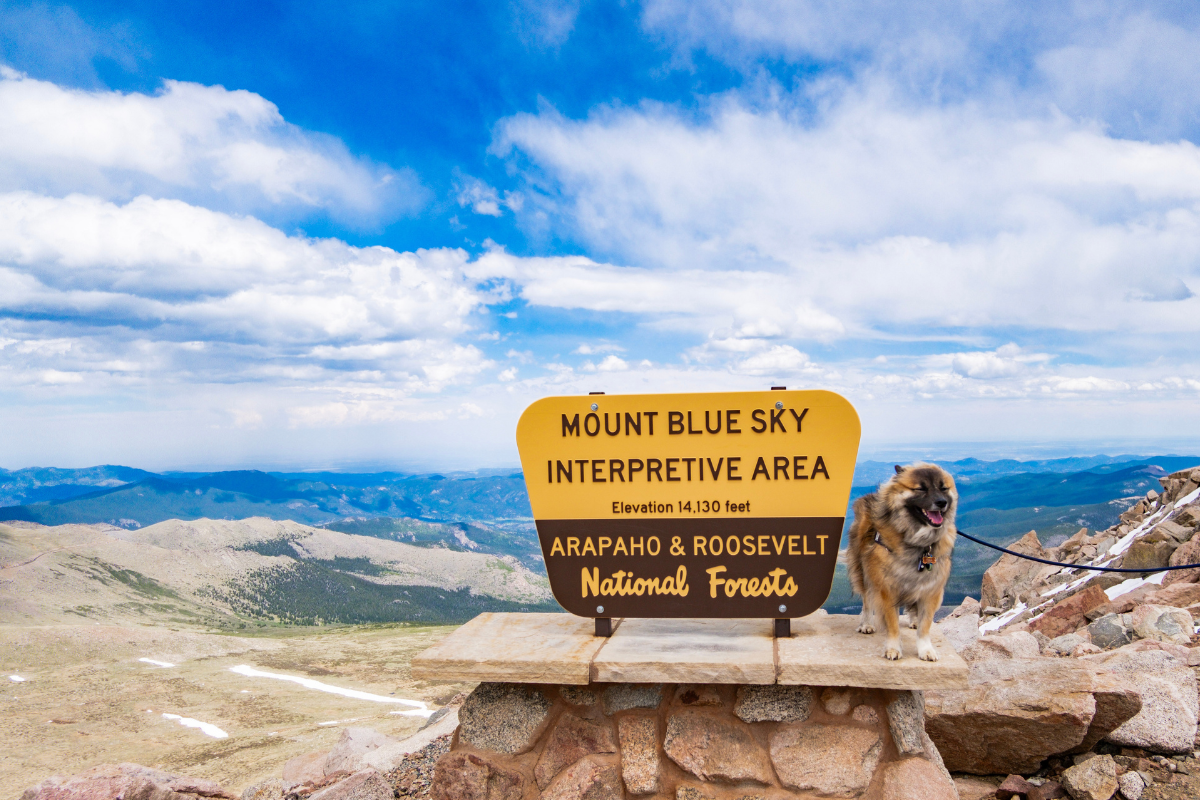
Some places impress you. Mount Blue Sky changed how we think about Colorado entirely.
In a single afternoon, we drove from alpine forest through subalpine meadows and up into true alpine tundra, the land above the trees, where the only things growing are wildflowers smaller than a coin and the mountain goats outnumber the people. It was incredible to actually see these biomes in real life, the same ones we learned about as kids in school.

We stopped at Summit Lake, walked to the Chicago Lakes overlook, and then climbed the final stretch of rocky trail to the true summit at 14,264 feet, where we stood among the fourteeners with the entire Rocky Mountain range spread out around us.
It was windy and it was breathtaking in every sense of the word. And here is the thing we keep coming back to: we only gave Mount Blue Sky an afternoon, and by the time we drove back down, we both agreed we should have given it the whole day. Consider that our first piece of advice.
This Mount Blue Sky guide covers everything you need to plan your own visit, including the 2026 reservation system, what to expect on the highest paved road in North America, the summit trail, and how to handle the altitude.
- Does Mount Blue Sky Count as a 14er?
- Reservations and Fees for 2026
- The Drive: Three Ecosystems
- First Time Driving a High Mountain Road
- Wildlife on the Byway
- Summit Lake and Chicago Lakes Overlook
- The Summit Interpretive Area
- The Summit Trail
- Altitude: Our Honest Experience
- Visiting with Your Dog
- How We Structured Our Day
- What to Bring
So, Does Mount Blue Sky Count as a 14er?
We want to be upfront about this, because we know how much that question matters in the hiking world.
The Mount Blue Sky Scenic Byway ends at a parking area at 14,130 feet. From there, a short rocky trail, roughly a quarter mile, climbs the final stretch to the true summit at 14,264 feet. When you reach the top, you will find the official summit benchmark marker, a brass geodetic survey disk embedded in the rock. That marker is the real deal. It is the same control point NOAA surveyors use to measure the mountain’s official elevation. The summit you are standing on is genuinely the summit.
But here is the honest part: we did not hike a 14er. Hiking a 14er means earning it from a trailhead, typically thousands of feet of climbing over many miles, and people who do that deserve every bit of the accomplishment. What we did was drive most of the mountain and walk the last short stretch. We stood on a true 14er summit at 14,264 feet, the 14th highest peak in Colorado and the highest point in the Mount Evans Wilderness, and that experience was incredible. We just did not climb it, and we will not pretend otherwise.

And honestly, that accessibility is the entire magic of Mount Blue Sky. Families, first timers, travelers still acclimating, and people who cannot hike a full mountain all get to stand on top of the Rockies here. If you want to actually hike Mount Blue Sky as a true 14er, established routes like the West Ridge from Summit Lake exist for exactly that. For everyone else, the road plus the short summit trail delivers a top of the world moment that very few places on Earth make this reachable.
Mount Blue Sky Reservations and Fees for 2026
You cannot simply show up and drive Mount Blue Sky. Timed entry reservations are required and the system changed in 2026, so even if you visited before, read this part.
The byway reopened over Memorial Day weekend 2026 after closing in September 2024 for major road reconstruction. Denver Parks and Recreation now manages the welcome station and reservation system.
- Book on Recreation.gov for the Mount Blue Sky Recreation Area
- $20 per vehicle for the all sites pass, $15 per motorcycle, plus a $2 processing fee
- Cyclists ride free if you are up for one of the most legendary road climbs in the country
- 75 percent of timed slots are released 30 days in advance and the remaining 25 percent open two days ahead, so there is hope for spontaneous trips
- America the Beautiful and other interagency passes do not skip the system. You still need a timed reservation and the $2 fee applies
- Print or download your reservation before leaving town. There is no cell service at the welcome station
- Bathrooms are available at Summit Lake and at the summit parking area. Use them when you can. There are no facilities in between.
We booked a 1pm timed entry, which gave us the morning for other adventures nearby. More on how we structured that day below, because it accidentally became our best altitude strategy.
The Drive: Three Ecosystems Through Your Windshield
The Mount Blue Sky Scenic Byway climbs more than 7,000 feet in 28 miles, and you watch the entire landscape transform as you go.
You begin in dense alpine forest around Echo Lake. As you climb, the trees thin and the landscape shifts. Near Mount Goliath Natural Area, you pass Rocky Mountain bristlecone pines visible from the road, some of the oldest living trees on Earth. Past treeline, the landscape opens into tundra. Watching the shift from forest to subalpine to open tundra in real time is one of the most striking parts of the drive, and it is all 60 to 75 minutes from Denver.

First Time Driving a High Mountain Road? Read This
We will be honest with you: this drive did not faze us, but that is because it was not our first high mountain road. We have driven Pikes Peak and other steep paved climbs, so the narrow lanes felt familiar. If this is your first time, here is what we want you to know going in.
- There are no guardrails. None. The road is narrow with steep drops, and the maximum vehicle length is 30 feet for a reason. Motorhomes are not recommended
- Drive slowly and stay in your lane. The views will tempt your eyes off the road. Use the pullouts. That is what they are for
- The driver does not get the views. Whoever drives up should swap or stop often. Plan for it
- Watch for cyclists. This is a famous road climb and riders share the full route
- Weather changes fast. Afternoon storms build quickly above tree line in summer. Earlier entry times are safer bets
- Use lower gears on the way down to save your brakes rather than riding them
If heights and exposure genuinely frighten you, the passenger seat on the inside lane going up is your friend, and you can absolutely still do this drive. Thousands of first timers do it every season. Go slow, take breaks, and let faster traffic pass at pullouts.
Wildlife on the Byway
Keep your speed down and your eyes open. Mount Blue Sky is famous for its mountain goat and bighorn sheep herds, along with marmots, pikas, and alpine birds. The animals here are remarkably unbothered by vehicles, which makes for incredible viewing and also means they will absolutely stand in the middle of the road like they pay taxes on it.
We spotted marmots darting off the roadside as we passed, a bighorn sheep that turned to give us a long, unbothered look on the way up, and mountain goats doing exactly what mountain goats do: standing in the middle of the road and causing a small traffic situation on a scenic byway at 14,000 feet.
One firm rule: never feed or approach the wildlife. Feeding or attracting wildlife is prohibited in the recreation area, and it genuinely harms the animals.


Summit Lake and Chicago Lakes Overlook
About two thirds of the way up, Summit Lake Park sits in a glacial cirque at 12,840 feet. This 160 acre park is the highest anchor in Denver’s Mountain Parks system, and it is worth a real stop, not a drive by.
It is one of the most stunning alpine lakes we have ever seen. There is something about the way the snow settles into the rocks and the water catches the light that is hard to put into words. We could have sat there all afternoon just taking it in. Do not rush this one.


From Summit Lake, a short trail leads to the Chicago Lakes Overlook, and this became one of our favorite moments of the entire day. We are from Chicago, so there was never any question about whether we were making this walk. Tired or not, we were going.
The overlook drops away into the Chicago Lakes basin, the lakes far below ringed by cirque walls. From here you can also see the Black Wall, a sheer 700 foot granite face that gets its name from the dark streaks left by snowmelt draining down the rock well into summer. It is a short, easy walk for a view that feels earned by something much harder. If you want to extend the day, it is also the start of its own full hike down into the basin.

Chicago Lakes Overlook Trailhead Sign 
Summit lake view from Chicago lakes trail 
Chicago Lakes seen from the Chicago lakes Overlook at Mount Blue Sky Colorado 
The Black Wall seen from the Chicago Lakes Overlook in Mount Blue Sky Colorado 
Please stay on loop trail Keep off fragile tundra sign at Summit lake in mount blue sky
One important note here and everywhere above treeline: stay on the trails. The alpine tundra is one of the most fragile ecosystems in Colorado. Plants up here can take decades to recover from a single footstep. There are signs posted throughout, and they mean it. Pack out everything you bring in, stay on durable surfaces, and leave the wildflowers exactly where they grow. These places are worth protecting so we can all keep coming back to them.
The Summit Interpretive Area
The road ends at the Summit Interpretive Area at 14,130 feet. From here you already have sweeping views across the Front Range, and this is where we had our closest mountain goat encounter of the entire day. They were right there among the rocks, completely unbothered.
There are three structures here worth exploring. The Meyer-Womble Observatory is one of the highest observatories in the world at 14,193 feet, run by the University of Denver. Next to it is the High Altitude Lab, a wooden A-frame built in 1935 for cosmic ray research. The Crest House ruins served as a restaurant until a fire in 1979 and now act as a windbreak. Bathrooms are available here as well. Use them before hitting the trail.


The Summit Trail: Standing Among the Fourteeners
A short rocky trail climbs the final stretch from the parking area to the true summit at 14,264 feet. It is uneven and exposed, and at this elevation every step costs more than it would at sea level. There is no prize for rushing it. Keep an eye out for marmots hiding in the rocks along the way.
It was quite windy up there, and we will not pretend otherwise. But we layered up, took it slow, and just absorbed the moment. Standing at the summit marker, you are not looking up at the Rocky Mountains. You are standing among them. Fourteeners in every direction, ridgelines stacked behind ridgelines until they fade into haze, and the plains stretching east until the earth curves away.
I will be honest: I got emotional up there. Full tears. I stood at that marker thinking about how all of this was formed, how small we are inside of it, and how humbled I felt just to be standing in it. I kept thinking about the version of me who never imagined she would one day live among these mountains, let alone stand on top of one. It may seem dramatic to some. To me it was everything. It is exactly why we love Colorado, and why we moved here.


Mount Blue Sky Altitude: Our Honest Experience
We want to be real with you here, because we have experienced both versions of this story.
On this trip, we managed well. Some lightheadedness and headaches along the way, but drinking water consistently and moving slowly kept things manageable. We also accidentally did something smart: we spent the whole morning at elevation before our 1pm timed entry, hiking Saint Mary’s Glacier at over 10,000 feet and wandering Idaho Springs at 7,500 feet. By the time we drove up, our bodies had been adjusting all day. If you can structure your day this way, do it.
Our first time up Pikes Peak was a completely different story. We went up too fast, felt truly sick, and I came close to fainting. You can read more about it in our Colorado Springs guide. The only thing that reliably helps is going back down. Lower elevation is the cure, and it works quickly.
Our honest advice:
- Do not make this your first stop on your first day in Colorado. Give yourself at least a day or two to acclimate
- Drink water before and during the drive, more than feels necessary
- Move slowly at the top. Slower than you think you need to
- Know the signs: headache, dizziness, nausea, unusual fatigue
- If someone in your group feels genuinely unwell, drive down. The summit will still be there
Altitude sickness does not care how fit you are. Respecting the mountain includes respecting what it does to your body.
Visiting Mount Blue Sky With Your Dog
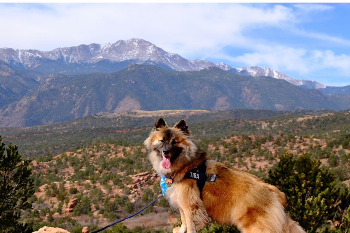
This was one of the most dog friendly fourteener experiences we could imagine, and Tira had the time of his life. His favorite part, without question, was the wind, ears back and fur rippling. He also got a chance to sniff the geodetic marker. We also loved seeing other dogs up there enjoying their own fourteener moment with their families.


The rules, which are taken seriously here:
- Dogs must be on a handheld leash at all times throughout the recreation area
- Dogs cannot be left in an unattended vehicle, ever
- Pick up after your pet and pack it out
Our own additions from experience:
- Watch your dog for altitude effects just like a person: heavy panting beyond normal, lethargy, or wobbliness means it is time to descend
- Bring water and a bowl for the summit area. We never travel without our collapsible dog bowl and dog water bottle with food container
- The rocky summit trail is fine for confident dogs, but keep the leash short around drop offs and wildlife
- The tundra rule applies to paws too. Keep dogs on trails and durable surfaces
For everything we pack for Tira, see our Pet Travel Gear page
How We Structured Our Day, and What We Would Change
Our day looked like this: Saint Mary’s Glacier hike in the morning, lunch and thrifting in Idaho Springs, then our 1pm timed entry up Mount Blue Sky for the afternoon. It flowed beautifully, the altitude strategy worked, and we still recommend that exact pairing if you only have one day.
But if we could do it again, we would give Mount Blue Sky the entire day. We drove past Echo Lake at the start, which in hindsight was a mistake. At 10,600 feet it has picnic tables, a short loop trail, and fishing and is worth a real stop. Mount Goliath Natural Area is another one we skipped, home to bristlecone pines that are up to 1,600 years old and a nature center run with Denver Botanic Gardens. Add Summit Lake, the Chicago Lakes overlook, the wildlife stops, and the summit itself and a full day disappears fast. Take the early entry, pack a lunch, and give it the time it deserves.
What to Bring to Mount Blue Sky
Even on a warm June day, the summit is cold and the wind is real. Our short list:
- Layers, including a true wind shell. The temperature difference between Echo Lake and the summit can be 30 degrees or more
- Sunscreen and SPF lip balm. UV exposure at 14,000 feet is intense even when it feels cool
- More water than you think you need, for people and dogs
- Snacks. There are no services on the upper mountain
- A camera with a full battery. You will use all of it
- Your reservation, downloaded or printed before you lose cell service
Final Thoughts on Mount Blue Sky
Mount Blue Sky truly impressed us, and that is not a phrase we hand out easily. It compresses everything we love about Colorado into 28 miles: the ecosystems, the wildlife, the scale, the feeling of standing in a landscape that does not care that you exist and is more beautiful for it.
Go early, book ahead, respect the altitude, stay on the trails, and give it more time than you think it deserves. It deserves all of it.


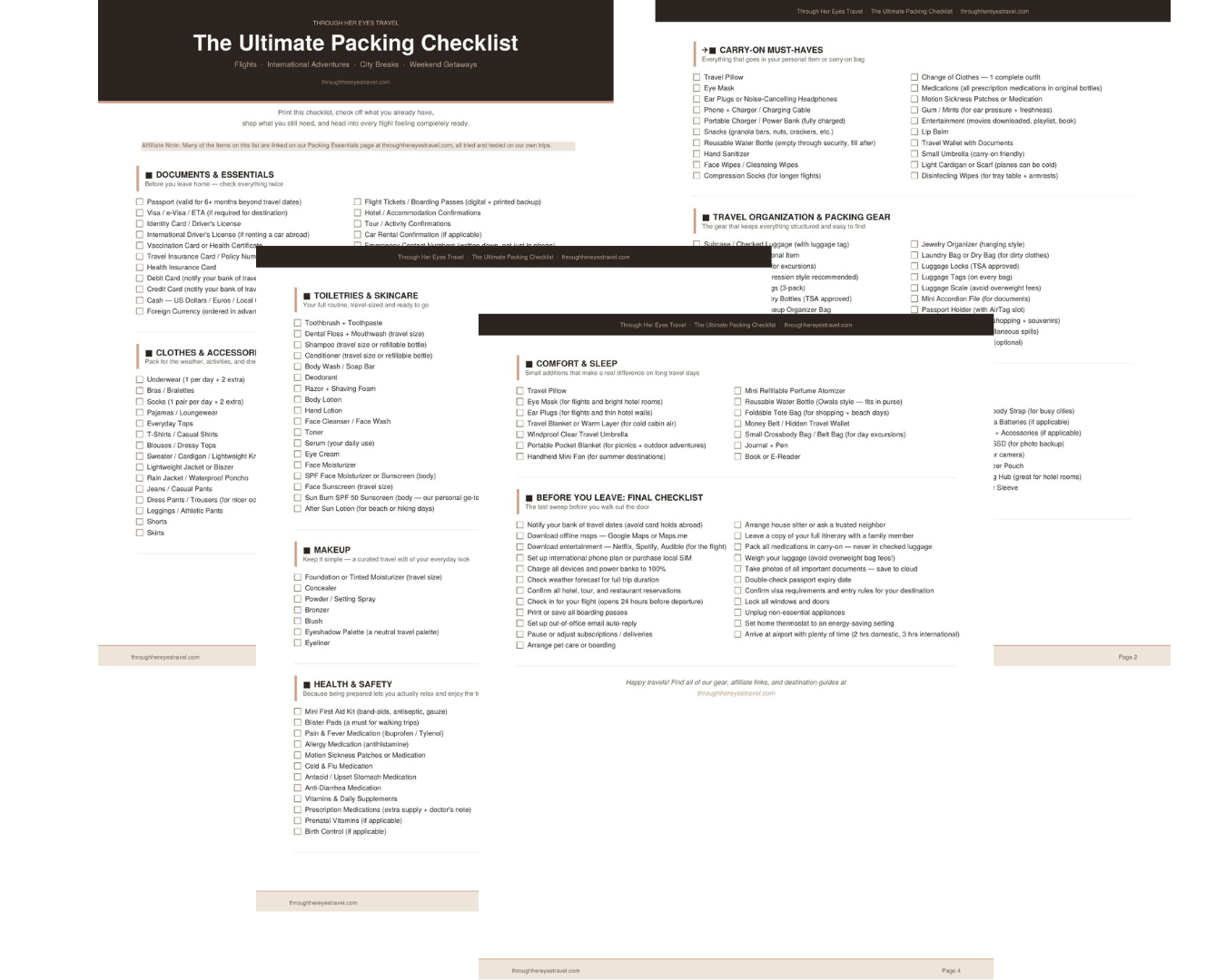
Free Download
Get the Free Printable Packing Checklist
It is completely free. Just drop your email below and we will send it straight to your inbox. Check off what you already have, shop what you still need, and head into every trip feeling completely ready.


Leave a Reply