
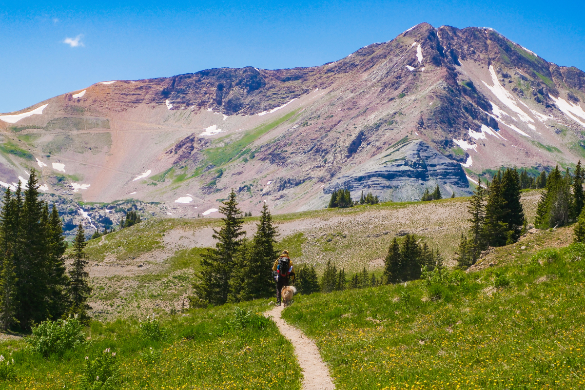
The Scarp Ridge Loop near Crested Butte ended up being the highlight of our entire trip, and fittingly, our anniversary too. We always try to do something epic to celebrate. Last year it was standing at the top of Pikes Peak during our Colorado Springs trip, and the year before that we were in Quebec City, Canada chasing after K-drama Goblin filming locations. This year, this hike was the one I had been most excited for on our entire Crested Butte trip. And what makes it even better, this hike is dog friendly.
Want the full experience? Watch the Scarp Ridge Loop come to life below:
Hiking Scarp Ridge Loop
Here is everything you need to know to plan your own Scarp Ridge hike, including the parking mix up nobody warns you about, what the trail is actually like underfoot, and how to handle it if this is your first time hiking at altitude in Colorado.
The Scarp Ridge Trail: What It’s Actually Like
This was definitely one of our favorite trails, and during this time it was beautiful with wildflowers covering long stretches of the trail. The trail passes through a few shaded, tree covered stretches, but as you climb higher toward the summit, it opens up into fully exposed ridgeline with no tree cover at all.

The trail is easy to follow for almost the entire hike. The only confusing spot is an unsigned junction near a large rock slab. We stayed on route by downloading the AllTrails offline map beforehand.
And if you are up for more of a challenge, you can extend this to Mount Emmons. That version is an 8.3 mile loop in total with about 2,585 ft of elevation gain, topping out at 12,343 ft on Mount Emmons itself. It is roughly double the distance and elevation gain of the loop we did.

The Views: Mount Owen, Ruby Peak, Green Lake, and Mount Emmons
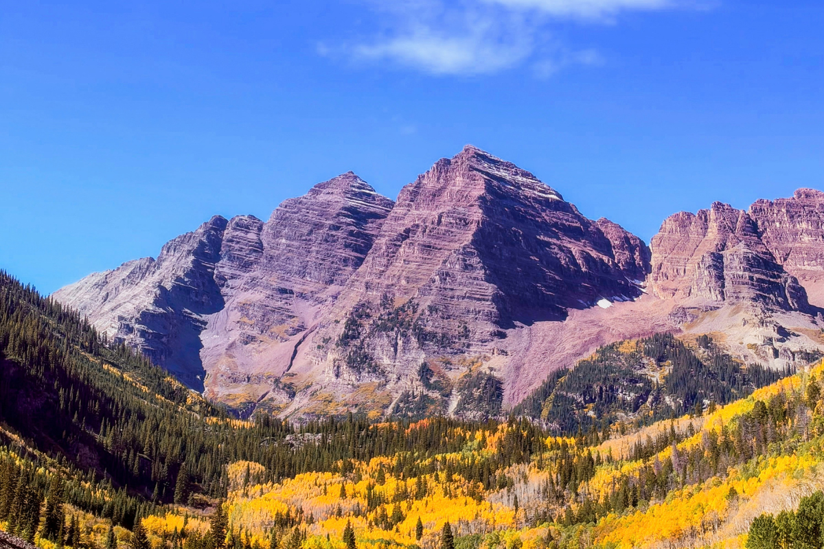
This was one of the most beautiful hikes we have done. From the summit, you can see Mount Owen, Ruby Peak with Green Lake sitting just below it, and Mount Emmons, known locally as Red Lady. Even though it’s ranked hard on AllTrails, we managed it just fine. Really, it comes down to the elevation gain more than the distance.
And as I always say, you have to do this hike yourself to truly experience it. The 360 degree views at the top are just incredible.

Hiking Scarp Ridge with Your Dog
This trail falls under Gunnison National Forest, where dogs are allowed off leash as long as they are under voice control. We let Tira off leash for parts of this one since he was comfortable, so if you are bringing a dog, that is worth knowing before you go.
- Bring more water for your dog than you think you will need, there is no water source on the trail
- Pack extra treats, the altitude and distance burn through their energy fast too
- Watch their paws on the rockier sections over a hike this length
- Plan for breaks along the way, dogs feel the altitude and terrain just like you do

Where to Park for Scarp Ridge: Don’t Make This Mistake
The 1 Mistake to Avoid: Don’t park at the old Irwin Lodge near the trailhead. Even though AllTrails directs you there, the area is clearly marked No Parking because it borders private property.
Instead, park at the roadside pull-off before you reach the lodge. Parking is limited, so arriving early gives you the best chance of getting a spot.
From the pull-off, simply walk up the road past the old Irwin Lodge. Just beyond the private property sign, you’ll see the trailhead post where the hike begins.
Parking coordinates: 1098 FSR 826, Crested Butte, CO 81224 (38.8854031, -107.1031716). We recommend entering these exact coordinates into Google Maps, as they’ll take you directly to the pull-off.
You’ll also see an option in AllTrails to park at Lake Irwin and walk up the road to the trailhead. That works if the pull-off is full, but it adds extra mileage to an already strenuous hike. We’d recommend trying for the roadside pull-off first and using Lake Irwin as a backup.
The drive to the trailhead follows the gravel section of Kebler Pass Road toward Lake Irwin. Some stretches have steep drop-offs with no guardrails, so take your time if you’re new to mountain driving. A high-clearance 4WD vehicle is recommended, but we also saw several AWD SUVs parked at the trailhead so those cars are able to manage it too.
How Crowded Is Scarp Ridge?
We hiked this on a weekday, and the whole time we only crossed paths with about five other groups, a mix of families and couples, most of them with dogs too. It never felt crowded, even at the summit, which is not something you can say about a lot of the more popular wildflower trails closer to town.
Pair It with the Rest of Your Crested Butte Trip
If you’re building this into your own Crested Butte itinerary, block off half a day for it. Between the drive out to the trailhead, the hike itself, and the drive back into town, this ate up most of our day two, and we still had energy left for dinner downtown afterward.
10 Best Tips for Hiking Scarp Ridge
1. Pace Yourself at the Altitude
You’re working up toward 12,000 feet, and if this is your first hike at altitude in Colorado, the effects are real even for people who consider themselves fit. Acclimate for a day if you can before attempting this one, save it for your second day in the mountains rather than your first.
2. Hydrate Before, During, and After
Not just on the trail. Start drinking extra water the day before if you can, and bring electrolytes along too, plain water alone isn’t enough when you’re sweating at this elevation. We bring Liquid IV packets on hikes like this. And don’t skip breakfast the morning of, you need the energy for this one.
3. Choose Sturdy Footwear
The terrain is loose and rocky in long stretches, so shoes with good grip and ankle support make a real difference on the descent as much as the climb. Trekking poles help too, especially on the loose sections where extra stability makes the footing feel more secure.
4. Do the Full Loop, Not an Out and Back
We went clockwise and it worked well for pacing, though we heard counterclockwise is better for the ascent itself. Either direction is more scenic than turning around partway.
5. Layer Up, Even in July
The elevation gain hits fast and it is windy near the top regardless of season. Something you can shed on the climb and put back on at the summit works best. And if you have long hair, a good hat and/or an updo helps, otherwise the wind will have it all over the place, especially in your photos.
6. Know the Warning Signs
Headache, nausea, and dizziness that don’t improve with rest and water are signs to turn around, not push through. Slow down more than feels necessary, your normal pace at sea level does not translate up here.
7. Bring a Leash and Use It on the Exposed Ridgeline
Gunnison National Forest allows dogs off leash under voice control, but near the top, the ridgeline gets quite steep, and there can still be patches of snow even in late June. Our dog Tira spotted the snow and couldn’t help himself, getting a bit too close to the edge chasing after it. If your dog isn’t rock solid on command, or you’re anywhere near the exposed sections at the top, just leash them. And even if you plan to go off leash the whole way, have a leash on hand, other hikers and their dogs may not want an off leash approach.
8. Start Early
Parking at the pull off is limited, afternoon storms roll in fast on exposed ridges, and the climb is much more pleasant before the sun is fully overhead. Starting in the morning gives you the best shot at a parking spot and gets you off the ridgeline before any weather builds.
9. Carry Bear Spray
Kebler Pass, Lake Irwin, and the surrounding Gunnison National Forest are known black bear habitat, so we made sure to carry bear spray with us. Hike in a group if you can, make some noise near tree cover, and keep food sealed rather than snacking with open wrappers on the trail.
10. Bring Real Sun Protection, Not Just Sunscreen
There’s very little shade once you’re on the ridge, so sunscreen alone isn’t enough. A sun hat, a sun protective hoodie, and sunglasses all earn their space in your pack, UV exposure is stronger at this elevation than it feels.
BONUS: STOP BY Lake Irwin on the way out
You drive right past it, so don’t skip it. The lake sits right along the road with the Anthracite Range behind it, and after five hours on the trail, it makes for the perfect wind down stop. If you somehow still have energy left, there’s an easy, mostly flat 1.65 mile loop around the lake. And if you want an early start on Scarp Ridge, Lake Irwin Campground sits right on the water, book ahead on recreation.gov since sites go fast in wildflower season.

Final Thoughts on Scarp Ridge Loop
Scarp Ridge during wildflower season was one of the most beautiful hikes we’ve done and definitely checks off the EPIC for our anniversary. We loved every second of it and Tira had the best time too. So if you are in Crested Butte we highly recommend this hike.
More Colorado Hiking & Camping Adventures

Colorado
First Time in Crested Butte: The Complete Wildflower Itinerary

Colorado
St. Mary’s Glacier: 7 Best Tips and 1 Mistake to Avoid

Colorado
Rocky Mountain National Park: The Ultimate 1 Day Itinerary

Colorado
Ouray Perimeter Trail: Dog Friendly Hike Guide

Colorado
Mount Blue Sky: The Highest Road in the US

Camping
Crawford State Park: Dispersed Camping Guide
Everything you need to pack for a pet friendly road trip, from snacks and gear to must-have items for your pup. Sign up below to get it free.
Free Download
Get the Free Printable Road Trip Checklist
It is completely free. Just drop your email below and we will send it straight to your inbox. Check off what you already have, shop what you still need, and hit the road completely ready.



Leave a Reply